
Blue Marble Geographics' GIS data processing application "Global MapperThe latest version, version 22, has been officially released.The major update for the first time in about a year makes it even easier to use.
table of contents
- 1. About Global Mapper
- 2. Points of Global Mapper V22 / LiDAR Module V22
- 3. Features of Global Mapper and LiDAR Module
- 4. Comparison with ArcGIS
- 5. Demo version of Global Mapper
- 6. Operating environment of Global Mapper / Lidar Module
- 7. License and version upgrade
- 8. About Global Mapper Frequently Asked Questions
1. About Global Mapper
Global Mapper is an application developed for both GIS / mapping specialists who handle maps and spatial data and users who need maps, and is used in various business situations such as education, transportation, and public institutions. It is being used.
1-1. Features of Global Mapper
-Low cost and easy to use geographic information system (GIS =Geographic Information System)
· Supports online access to Dataset Search and formats of over 300 spatial data
-Intuitive operation and comfortable operation by user interface
-A convenient editing tool for data processing
・ Visualization of spatial data and excellent analysis function by cutting-edge 3D technology
-Visualize oil and gas on a map and calculate volume
・ Training and technical support
1-2. Global Mapper Options
・ Global Mapper LiDAR Module
Global Mapper LiDAR Module specializes in laser surveying (LiDAR) processingAn extension tool (add-on) for advanced point cloud processing.Create 3D point cloud data from overlapped images,Includes advanced point cloud processing tools such as automatic and manual point cloud classification and 3D data processing from aerial images. To use the LiDAR Module, you need Global Mapper of the same version and the same license type *.
* For exampleIf you have a Global Mapper USB Dongle License and want an additional LiDAR Module, you will need to purchase the LiDAR Module USB Dongle Licenses.
・ Global Mapper Mobile
A free app for iOS and Android devices for field display and data collection.
* Global Mapper MangoMap,Please contact us for Global Mapper SDK and LiDAR Module SDK.
2.Global Mapper V22/ Lidar Module V22 points
Various features have been added to the new version (V22) of Global Mapper and LiDAR Module.In addition to updating existing functions, we will introduce five important functions among the newly added functions.
2-1.New features in Global Mapper V22
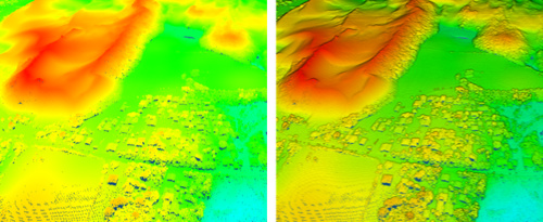
1: Improve the visual display of vector and LiDAR data with Eye-Dome Lighting (EDL) in 3D viewer
Eye-Dome Lighting (EDL), a display option in the 3D viewer, enhances the perspective of the texture and enhances the perception of depth by darkening some renderings.
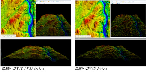
2: Add tools to simplify loaded meshes or triangulated irregular networks (TINs)
If the triangular faces of the mesh feature do not significantly affect the shape of the scene, combine them to reduce the number of faces and vertices in the mesh, simplifying and reducing the size.
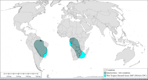
3: Spatial Operations tool for posting layer intersections
Analyze the relationship between locations that meet two or more criteria (overlapping vector data) to determine where multiple features coexist.
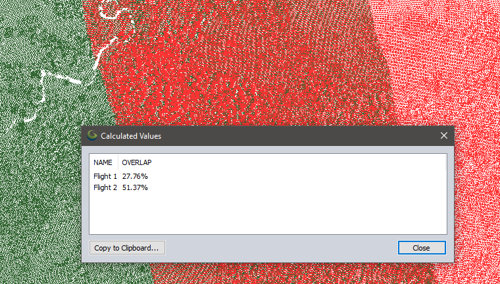
4: Analysis menu option to find overlap
An analysis option for finding overlaps (both percentages and graphics) between two or more LiDARs, rasters / images, and Terrain Layers.You can create a report that shows the overlap rate between layers.
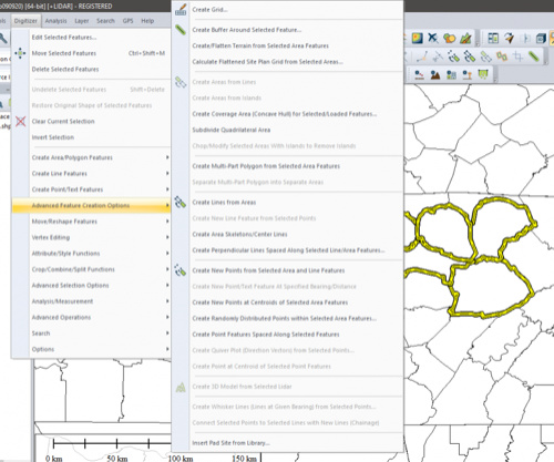
5: Improved digitizer menu (smooth access to digitizer function)
The digitizer menu provides easy access to all the tools needed to work with vector data.It includes everything from creating simple points, lines and area features to advanced 3D mesh editing capabilities.It also helps streamline your workflow.
Top 5 New Features of Global Mapper v.22
https://blog.bluemarblegeo.com/2020/09/17/top-5-new-features-of-global-mapper-v-22/
In addition to the above, the Raster Reclassify tool, which allows you to manipulate continuous data (terrain / tilt, single band of images), has been updated, and 3D rendering has become faster (XNUMXD rendering).Rendering of tiled online data sources) and so on.
2-2. Global Mapper LiDAR ModuleNew features of
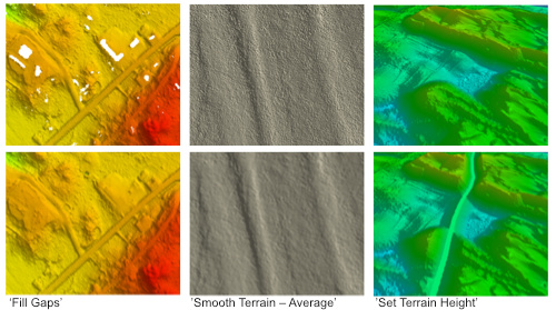
1: Terrain Paint tool (Terrain Paint Tool)
You can interactively change the elevation values of a gridded elevation dataset, such as filling terrain gaps, raising or lowering existing elevations within a defined area, or setting specific elevations. "'Fill Gaps' = fill gaps" to fill the missing areas of terrain, "'Smooth Terrain – Average' = smooth terrain-average" creates a cleaner terrain surface, and "'Set You can create a road simulation path with Terrain Height'= Terrain Height Settings.
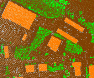
2: building classification (New algorithm to improve building classification)
LaDAR ModuleAutomatic function identification and updated algorithms for identifying buildings in point cloud data (point cloud) allow you to more accurately reflect building data when working with point cloud data from any source.
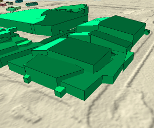
3:Improved building extraction by simplifying 3D shapes
Significant improvements in the vectorization algorithm have made the contours of the object's buildings more accurate.
4:Options for generating process summary reports when using the Pixels to Points process
An HTML-formatted "post-processing report" that briefly summarizes relevant information from the data generation process includes an overview of input data, processing time, output data, quality evaluation, and visual representation of individual output layers. ..You can open the report in a web browser and save it as a PDF file.
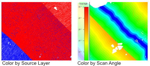
5:Two new coloring modes (LIDAR draw mode)
You can apply a unique color to the point cloud layerColor by Source Layer And color coding using the scan angle attributeColor by Scan AngleThe two allow you to clearly distinguish between individual layers of point classification / point attributes.
Top 5 Features of Global Mapper's Lidar Module Version 22
https://blog.bluemarblegeo.com/2020/09/22/top-5-features-of-global-mappers-lidar-module-version-22/
3. Features of Global Mapper and LiDAR Module
Standard features of Global Mapper
-Supports reading / writing of point cloud data (LAS / LAZ files)
・ Supports work exceeding 10 billion point data [64bit only]
-Option to render point cloud
Depending on the elevation shader, RGB value intensity embedded in the point cloud, classification, return number, point index, point source ID, difference in height between first and last returns, calculated NDVI or NDWI value (NIR attribute) necessary)
・ Function to reproject LiDAR point cloud
・ Function to trim the point cloud
-Ability to manually edit or delete points
-Creating an elevation grid using the TIN method
Features that can be added by the LiDAR Module
-Pixels-to-Points Tool for creating 3D point clouds from overlapping images
· Leica PTS format support
-Point cloud data rendering options (ground height, point density)
-Ability to interactively change the rendering method from the toolbar
・ Coloring of one-button point groups from raster images, etc.
LiDAR Module vs. Global Mapper (Manufacturer Page)
https://www.bluemarblegeo.com/products/global-mapper-lidar-feature-comparison.php
4. Comparison with ArcGIS
Like Global Mapper, one of the most popular GIS software is ArcGIS.
The Blue Marble Geographics website has a comparison table of GlobalMapper and ArcGIS.
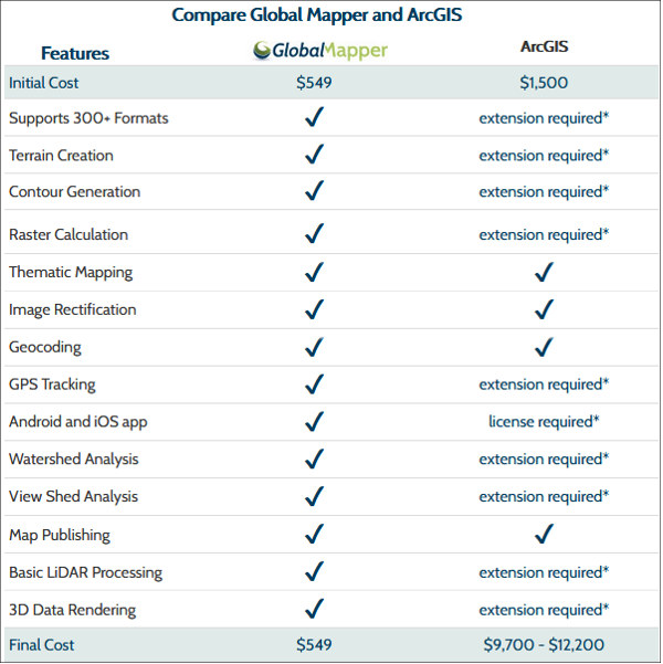
Features that are made available by extension in ArcGIS can be used in one application without the need for extension in GlobalMapper.
Global Mapper vs ArcGIS
https://www.bluemarblegeo.com/products/global-mapper-arcgis.php
5. Demo version of Global Mapper
Global Mapper is free to use for 14 days.
Download the trial versionHere (manufacturer site) .
6. Operating environment of Global Mapper / Lidar Module
・ Windows 8/10
・ Windows Server 2012/2016/2019
・ RAM: 4GB or more
-HDD: 500MB or more free space
7. License and version upgrade
Global Mapper is a perpetual license.Blue Marble Geographics maintenance and support (Maintenance) includes access to major releases and technical assistance within a year of purchase.If you wish to maintain it, you will need to renew it annually.
We also offer upgrade licenses from older versions to v22.xx.If you wish to upgradePlease let us know the license information you currently own.
For details on the license, please seeLicense Terms (Manufacturer Page)Please Confirm.
7-1. License transfer
If you need to transfer the license due to replacement of the PC, you have to uninstall the software from the existing PC. With the release of V22, older versions (V20 and earlier) can no longer be downloaded from the manufacturer page.Before replacing the old version, be sure to check if the installation file of Global Mapper you own exists.
8. About Global Mapper Frequently Asked Questions
We have some of the questions and answers we received from our customers regarding Global Mapper.Support siteIt is published in.
The manufacturer's knowledge base is also substantial, so please refer to it.
| ■ Click here for product details and inquiries Global Mapper / GIS data processing application Manufacturer (Blue Marble Geographics) WEB site |